Lethal combo of natural fury crushed Wayanad, experts call for 'run-out' analysis

Mail This Article
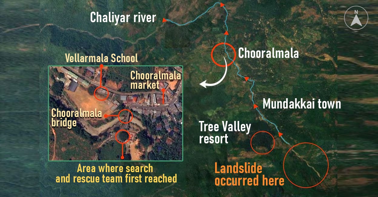
High risk, whole village, special attention required at Mundakkai,Vellarimala, forest area, Hope Estate, thus reads the natural hazard zonation of Wayanad in the district disaster management plan prepared in 2019. Among the five disasters, landslide and flood were categorised as high risk for Mundakkai which falls under Vellarimala village, but nothing prepared the village and the authorities for what unravelled in the early hours on Tuesday. An abnormally huge mass of debris barrelled downwards crushing houses, people and a town.
Propelled by a high intensity rainfall in areas around Mundakkai that measured an alarming 350 mm in 24 hours, the run-out distance (distance traversed by the debris from the point of origin up to the farthest point of impact) of the landslide measured around 6 km. Officials with the State Emergency Operations Centre (SEOC) said the combination of factors was lethally similar in case of landslides that had happened at Puthumala and Pettimudi -- extreme precipitation, long run-out distance, steep gradient of slope.
As rainfall happens, water infiltrates the soil pores and the pore pressure builds, causing soil layers to slide. At Mundakkai, an excessively large quantity of earth got saturated, the pressure was so high that it assumed a momentum and width large enough to swallow up whatever that came on the way. The landslide just got longer, wider and farther in Wayanad leading to unprecedented damage.

''We knew where the landslide could happen, but what we don't know is how far it could travel. The run-out distance in the latest instance was really long. When that happens, all water in the area flows towards the high pressure point. The slope enhanced the flow. The run-out distance attained by this flow widened the area of devastation,'' said assistant professor in geology department of Kerala University Sajin Kumar K S, who has extensively researched on landslides in the state.
The nature of soil in Wayanad was the perfect foil to the disaster. ''The run-out distance depends upon volume of material as well as forces which stir them forward. In this case, the force was the rain intensity. In Wayanad, the impact was severe because of the soil profile. It is a silty type with slippery texture. Normally we have a rock basement and top of which there is a weathered rock covered by a soil profile which will be 1-1.5m thick. In Wayanad this soil profile is almost 5m thick. Flow of such a mass of soil would be enormous. Also the rainfall was almost three times excess within a short span of time. The pore pressure combined with a thick soil profile in the event of extreme rainfall proved dangerous. It is almost like a dam burst,'' said G Sankar, former scientist with the National Centre for Earth Science Studies.

Presence of sufficient drainage network could alleviate the impact and in the absence of such outlets to dissipate the pressure, the eventual impact is like a stampede. ''Imagine a huge crowd trying to make their way out of a theatre through a single, narrow exit. The pressure builds up and it could erupt,'' said Sankar.
In the wake of long landslides and run-out distances of the debris flow, the experts are calling for landslide run-out analysis based on modelling of previous events. This would give a fair idea on how far debris could reach and cause devastation. A study published in Canadian geotechnical journal notes that it involves forensic-style back-analysis (simulation) of previous events and the forward-analysis (prediction or forecasting) of potential future events.

The paper narrates an instance from 2010 -- Mount Meager rock slide -- debris flow in southwestern British Columbia. Approximately 50X106m3 of weak volcanic rock failed on the flank of Mount Meager and travelled down Capricorn Creek, reaching estimated velocities of over 80m/s (290km/h), before temporarily damming Meager Creek and then Lillooet River more than 12km from the landslide source. The risk of a sudden landslide dam outburst flood on Meager Creek forced the temporary evacuation of 1500 residents from the lower Lillooet River valley. The dam breached calmly within a couple of hours. Despite the substantial direct economic costs, the outcome of the Mount Meager event was very fortunate in the sense that no lives were lost.
Officials with SEOC, however, point out that there are practical concerns. ''Even if we tell people that debris could travel 6-7km, they won't move out. Because from the recent incidents, the point of origin of fatal landslides was quite far away from human habitation,'' an official said.


