Cyclone Burevi makes landfall in Sri Lanka, to cut through southern TVPM on Dec 4

Mail This Article
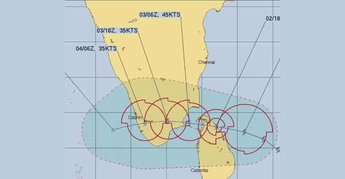
Tropical cyclone Burevi is expected to sweep across southern Thiruvananthapuram probably by the morning of December 4 (Friday).
The cyclone's path could make a latitudinal or horizontal cut through the south of Kerala, whooshing over areas near or around Neyyattinkara and Parassala, as it makes its predicted east-west arc from its origin over southwest Bay of Bengal.
By around 2.30 p.m. on Wednesday, the cyclone with a less than moderate speed of 15 kilometres per hour (km/hr) was found over the Bay of Bengal some 110 km east-northeast of Trincomalee (port city in northeast Sri Lanka), 330 km east southeast of Pamban (Rameshwaram, Tamil Nadu) and 520 km east-northeast of Kanyakumari.
The latest IMD bulletin (4.30 p.m.) said that the cyclonic storm was very likely to move west-northwestwards and cross Sri Lanka coast, just north of Trincomalee, at least by night today (December 2) with a wind speed of 80-90 km/hr but with sudden and unexpected gusts reaching even 100 km/hr.
From there, the IMD bulletin said it was "very likely" to move nearly west-northwestwards, emerge into Gulf of Mannar (near the southeastern tip of India) and adjoining Kanyakumari by the morning of December 3.
By December 3 noon, Burevi will be centred over Pamban with a wind speed of 70-80 km/hr and gusting to 90 km/hr. "It would then move nearly west-southwestwards across Pamban area by afternoon and cross south Tamil Nadu coast between Pamban and Kanyakumari during the night of December 4 and early morning December 5 with a wind speed of 70-80 km/hr gusting to 90 kmph.
The IMD bulletin said Burevi's impact on south Tamilnadu coastal districts was very likely to commence from the forenoon of December 3, initially over Ramanathapuram district and gradually towards Kanyakumari district.
What is of relief is that the cyclonic storm would lose speed as it passes over land. When it enters Sri Lanka, it is expected to have a speed of 80-90 km/hr. But as it crosses Tamil Nadu, the speed would lessen to 70-80 km/hr.
The storm is expected to cut through Kerala on December 4 and by then its speed would have reduced to 50-60 km/hr.
Though the storm would be moving only through the southernmost tip of Thiruvananthapuram district, it is expected to trigger rainfall at most places in South Kerala (Thiruvananthapuram, Kollam, Pathanamthitta and Alappuzha) with heavy to very heavy rainfall at few places and extremely heavy fall at isolated places.
Here are some damages Burevi is expected to inflict in South Kerala. One, damage to thatched huts. Two, minor damage to power and communication lines due to the breaking of branches. Three, major damage to Kutcha and minor damage to Pucca roads. Four, some damage to paddy crops, banana, papaya trees and orchards. Five, seawater inundation in low lying areas after the erosion of Kutcha embankments.
PM speaks with Tamil Nadu, Kerala CMs, assures all support from Centre

Prime Minister Narendra Modi spoke with the chief ministers of Tamil Nadu and Kerala on Wednesday and discussed the situation prevailing in parts of the states due to cyclone Burevi while pledging all possible support from the Centre.
The cyclone is likely to hit Tamil Nadu on December 4, the Cyclone Warning Division of the India Meteorological Department (IMD) said on Tuesday. The IMD has issued a red alert for south Tamil Nadu and south Kerala for December 3.
Tweeting about his telephonic conversation with Tamil Nadu Chief Minister K Palaniswami, Modi said, "We discussed the conditions prevailing in parts of the state due to Cyclone Burevi. Centre will provide all possible support to TN. I pray for the well-being and safety of those living in the areas affected."
On his talks with Kerala Chief Minister Pinarayi Vijayan, he said he spoke on the conditions prevailing due to cyclonic storm Burevi in the state and assured all possible support from the Centre to help Kerala.
"Praying for the safety and well-being of those staying in the affected areas," Modi said.

