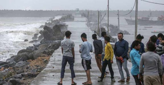
The fury of the wind god, Vayu, seems to have nearly died down over the Indian Ocean. Just as Vayu's anger looks spent, bang opposite over the Bay of Bengal, a low pressure formation that could fuel up the monsoon has been gaining strength. The southwest monsoon, therefore, is poised to regain strength from June 19.
The intense cyclonic formation, Vayu, off the western coast had all this while deflected the course of the monsoon-laden winds. Ever since it was formed on June 12, Vayu had pulled towards it the winds that should have moved diagonally from the southwest to the northeast.
In other words, Vayu did not allow the southwesterly winds to pass right through Kerala, ram straight into the Western Ghats, and shoot up to form monsoon clouds. Instead, the winds, sucked up by the cyclonic vortex, swerved left and took a near perpendicular route parallel to the western coast of the peninsula.
“The moisture-laden winds just scraped the Kerala coast and did not penetrate deep into the inland areas. This was why only the southern coastal regions in the state got bouts of heavy rainfall,” said Manoj, a weather expert working in CUSAT, Kochi. Only the coastal regions in the southern part of the state and Thiruvananthapuram received heavy rainfall. Never before has Thiruvananthapuram received such excess rainfall during monsoon.

Had Vayu been formed further east over Indian Ocean, the rains would have been deficient even in coastal areas. “Fortunately, the system was near Lakshadweep when the southwesterly winds hit the Kerala coast,” said S Abhilash, a weather researcher.
For the monsoon to penetrate inland, the wind movement should have adhered to what in meteorological jargon is called the orographic rainfall pattern. Orographic rain is nothing but rain produced from the lifting of moist air over a mountain. In this case, the rising up of the southwesterly winds over the Western Ghats.
Now, the formation of a low pressure area over the Bay of Bengal on the eastern side is expected to aid this orographic behaviour. “Once the low pressure becomes intense, it will draw winds from the west towards it causing the speeding moist air to get blocked by the Western Ghats and rise up to form monsoon clouds,” Manoj said. In footballing terms it would mean the Western Ghats chesting the westerly winds and kicking it up to form dark rain clouds.

The potency of the Bay of Bengal low pressure system will increase with the fizzling out of Vayu. There will be no competitive meteorological system to neutralise its effect. “The system (Vayu cyclone) is very likely to weaken into a depression during next six hours,” an Indian Meteorological Department (IMD) bulletin published at 12 noon on Monday said. “It is very likely to move northeastwards and cross north Gujarat coast by midnight of June 17 as a depression,” the bulletin said.
With the vanishing of the cyclone, the monsoon trough along the western coast of the Indian peninsula is also expected to become prominent. “This trough will pull the winds from the Arabian Sea and together with the winds lured by the Bay of Bengal low pressure system, they will cause more rainfall in the interiors of the state,” Manoj said.
Experts also say that southwest monsoon this time will at least be near-normal. The second and the more accurate long-range forecast by the IMD had pegged the monsoon performance at 96 per cent. For the southern peninsula region, which includes Kerala, the IMD's rating is 97 per cent.


